
An late Autumn warmer along this flat and marshy nature reserve.
For a 5 mile route, this felt much longer. Maybe it was the flatness of the gunmetal sky, the low sun or advancing chill of dusk. Maybe it was because I kept stopping to take pissing photographs in the cold, but this route definitely blew away the cobwebs on a chilly Sunday. We took the train to Pitsea from London Fenchurch Street, which you can do in 39 minutes on the fast service, or just under an hour otherwise.
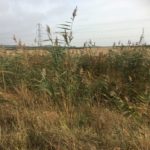
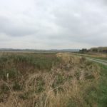
Pitsea itself didn’t make a striking impression on that barren sort of day, but I’m sure it could have said the same for us. A quick Google and Pitsea lays claim to a very large Tesco as well as Scott from 5ive. The flyover separates the station from this town proper, so not giving our host destination the chance, we quickly depart and join a footpath that follows the railway line East towards Canvey Island. The beginnings of winter are startlingly present here, as we hug the low vegetation for a windbreak. To our left (the South) a scant couple of miles, the Thames Estuary rushes forth to meet the sea and is joined by the many creeks that intersect the marshland here.
We’re heading in the direction of Pitsea Tip. Often accused of some stinky odours by nearby residents, environmental studies have dismissed local noses as fanciful. Nevertheless, London has been dumping rubbish here since Dickens was alive. It’s the second largest landfill site in the country and we see PLENTY of crap in this walk of two halves. Bear with us though, for tempering the sadness of this once biologically destitute location is the truly lovely spectacle of RSPB Bowers Marsh, proving that wildlife isn’t put off by all our human crap. They’ve taken on the challenge of environmental regeneration in this area with aplomb the last half century. Indeed when Pitsea Tip closes in the next decade, there are plans afoot to turn this into another nature reserve. I rather like the idea of a skylark nesting atop a KitKat wrapper I discarded in 2009, I really do.


We cross Church Road. You can shorten the route a little by just following it South (right) down towards the point at which we rejoin it later, but then you’ll miss the church.
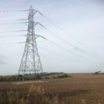
The next big feature in our route is St. Margaret’s Church in Bowers Gifford. Built in the 14th Century, this building still has some original stonework remaining, as well as its bells which are still in regular use! The tower and wooden spire were added later in Tudor times. After crossing church road, just a sniff South of the flyover, we pass through the churchyard and rejoin the path. We pass under the first mighty buzzing 400 KV high voltage electricity line. Pylons give me the willies and are the downside of this route, for me. I swear some sort of interference is the reason my GoPro goes flat really early on in this video. I swear it with all the clout of a combined Science GCSE.
Anyway, beyond the humming threat of this silent monster, we continue until the path leads us on to Jotmans Lane. I took a wrong turn here on account of the big sign saying ‘PRIVATE’, but you just need to take a right and follow the path round the perimeter of Rookery Farm. Doubling back on ourselves the footpath chucks us back out on Church Road, just North of RSPB Bowers Marsh car park.
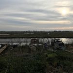
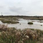
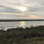
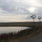
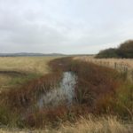
After this point, we enter the Nature Reserve and, sandwich in hand, follow a circular route around this rather magical place. Given that we are on the crest of November, the low sun just sparkles across the tops of the reedbanks. You have to slink beneath two more powerlines, but we followed the creeks all the way along the edge of Pitsea landfill. We saw bags of birdlife, galloping horses and the very pretty windmill water pumps at the South of the reserve. I only wish the camera had lasted to share this in the video. Instead you’ll see a montage of photographs of the Marsh in that golden sunlight – quite a painterly scene – and following that the approach to Benfleet station, South of a waste water plant.
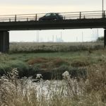
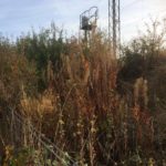
The latter part of the journey tended to drag a little, as the bits of rubbish scattered everywhere really started to become its own landscape. Broken boats and timber mingled with the dead Autumn foliage in a mish-mash of man-made and natural litter. When North of the reserve, you follow the footpath underneath the A130 Canvey Way and can see all the way South to the misty spectre of the former Coryton Refinery – one of the Thames Estuary’s last oil refineries – which ceased operating in 2012. A look at this stuff from above gives a really breathtaking view of the scale of work here (thank you Google). Indeed if you were an alien invader you might take one glance at the circuitry of this operation and think ‘No thanks, I’ll go for the Lakes instead’ and yet it is the scale of things which gives this landscape its barren appeal. Being a Southerner, I am quite sheltered from flat open spaces, and indeed fascinated by them as a result. The sadness of this part of England, coupled with the exciting plans to redevelop it’s biodiversity and regenerate towns and industrial areas, makes for quite a compelling walk. And there really are some pretty vistas to be captured all the same. Z for Zachariah it may feel like, on a moody, wintry Sunday, but there is still magic here.