
September 2014
Runviewer takes to its bike for this little slice of Peak District heaven. Not only does this route cover our number 2 favourite thing: a disused railway line, it concludes with our number 1 favourite thing: CAKE, Derbyshire style.
We join the Monsal Trail at Chee Dale, having walked from Buxton. I’d advise driving to Blackwell Mill (Wyedale) and hiring your bike from there if you’re coming from that direction, only because there is plenty of parking, or a bus stop if you’re using public transport. It’s about a 15 minute walk to the trail from there.
From there, the 8.5 mile long trail wends its way to Bakewell, accompanied by the river Wye, past some of the most beautiful countryside you’ll see in your life. And old railway stations, let’s not forget.
There are seven tunnels along the route, which, if you’re visiting in the snow, are absolutely haunting, not least because of the heavy icicles that drip from the ceiling, and cling to the rocky escarpments either side… or indeed the signs that tell you the lights will be switched off at dusk. Eeek.
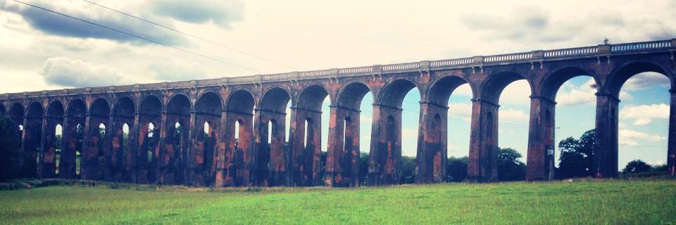
The view of Monsal Head from the Headstone viaduct is the reward that meets you as you plunge from the darkness at one such tunnel. Along the way you’ll spot Litton Mill – a wonderful looking 19th century textile mill where awful things happened to orphan workers.
The route ends just North of Bakewell, land of the pudding and dutifully sporting a tasty souvenir shop to that effect. Apparently it couldn’t end IN the village or pass anywhere near the grounds of Chatsworth House because the Duke of Devonshire didn’t want an ugly railway all over his land when they built it. He later changed his mind, but it was too late, so had to settle for the inclusion of Hassop station for his own purposes instead. #dukedrama
Just a note on getting back. If you’re coming back the way you came, well that’s all well and good, but if it’s a taxi you’re looking for they’re not as easy to come by in the rain as in London. This I discovered, to the detriment of a Bakewell pudding one time.
RUNWALKING
We coined the phrase ‘Runwalking’ in the Peak District, where we realised trotting along in our sportsgear, stopping for the view, rambling a bit, picnicking and photo-taking before picking up the speed again, is the most efficient way of covering miles and miles of this beautiful part of the world without running out of energy.
AMENITIES
Well, this DOES get important when you’re in the middle of the Peaks with intermittent phone signal, doesn’t it.
There are plenty of opportunities to dive off the path to the towns and villages along the way, and naturally your ordnance survey map is a good friend, but assuming you’ve saved this page offline and are using the rather handy one above, here’s a run down.
Loos – Millers Dale car park, Tideswell Dale (1 mile) Monsal Head (10 minutes from the trail), Bakewell (15 minute walk into the town centre)
Tuck Shop / Cafes – Along the way you’ll find refreshments at Wyedale, Millers Dale, Monsal Head and Hassop. Millers Dale and Hassop are the more civilisationy of the lot, depending on what you’re after.
Parking – There’s pretty much a way of accessing the trail from every town along the way but Wyedale, Miller’s Dale, Upperdale, Hassop and Bakewell are the closest to the path. They’re pay and display.
For more Peak parking advice, here’s a useful link. Click here.